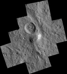
Today, NASA and the Dawn team have released a first look at Ahuna Mons, the giant mountain of Ceres, as captured in the Low Altitude Mapping Orbit or LAMO. While slightly distorted for the mosaic, the images appear to be at the maximum, 35-meters per pixel resolution capability of the Dawn mission in this phase.
 |
| PIA20348 |
The terrain at the top of the mountain appears to be very rough, with a large number of scarp-like carvings throughout. In contrast, the slopes around the mountain appear exceptionally smooth, free of any craters. This may be an indication that most of the slopes are screes, and only gravitationally stable.
On one side, bright material is present and seems to stream down the slope. The origin of this material is not clear but may be related to the crater at the far right of the summit, just to the left of the bright material. The origin of this crater is also not clear. It may be impact related or possibly volcanic in origin - either could have resulted in the bright material on the connecting slope.
The nearby crater to the north of Ahuna Mons also remains slightly puzzling. In numerous other craters on Ceres, mass-wasting events have lead to the floor of the crater being obscured and the rim of the crater degraded and slumping inward. The crater north of Ahuna Mons seems to be atypical to this normality, having an obscured crater floor and interior slopes as exceptionally smooth as the surrounding slopes of Ahuna Mons. Such smooth slopes within a crater also typically correlate with a recent impact. However, much of the former smooth ejecta blanket surrounding this crater, is rather degraded with numerous impacts across the terrain, contradicting the possibility of a recent impact.
One possible explanation could be that the the area surrounding Ahuna Mons is very soft and loosely held together like gravel or lunar soil, unable to retain a deformed state. However, an unknown material with a much stronger composition would need to be present within Ahuna Mons for this to be possible.
 |
| PIA20349 |
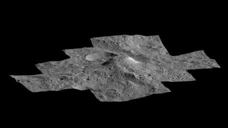
The team also released a synthetic oblique view. This image was created by using multiple images from the Framing Camera to derive altimetry data products such as a topographic map and a digital elevation model (DEM). For the oblique view, it appears the latest HAMO DEM was loaded into 3D space and textured with the latest LAMO images of the region.
In this synthetic oblique view, we can see a slight depression in the left most portion of the summit. Centered within this depression appears to be a central peak of sorts. Whether this is an indication that a crater was once at the summit in this location, now heavily deformed, is unclear.
Below is an cropped, enhanced view, similar in processing to the contextual images I regularly post.


No comments:
Post a Comment